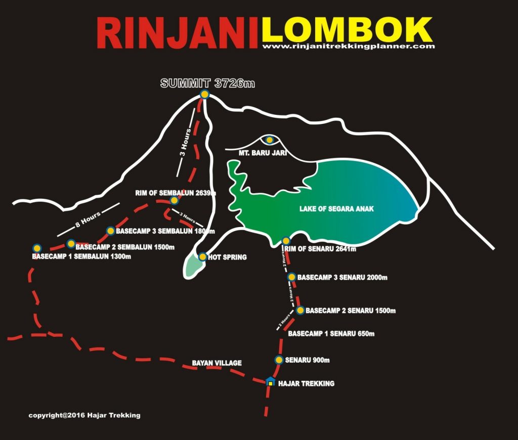
Rinjani trekking Route via Senaru Gateway
This is by far the most used Rinjani trekking route as it allows the (relatively) less strenuous trek to the crater rim.
You start at an elevation of 600 m in Senaru village, normally in the late morning or early afternoon and make the 6 hour ascent to the crater rim before dark.
First part of the trekking route a trek is through tropical rain forest. Look and listen out for the Lutung, or black monkey, swinging through the trees in the late morning. They are extremely shy, unlike for the common macaques which may gather near rest stops waiting for scraps.
The route passes through Pos 2 at 1,500 m, breaches the treeline at 2,000 m (Pos 3) and then it is a bit of slog up gravel paths to the camp site just below the crater rim at 2,600 m.
There is no clear path at the last section nearing crater rim, at an incline of 45 degrees. There is a Pos Extra after Pos 3, but it is pretty much gone, and the remaining bits have been chopped up by porters as firewood.
If that has not sapped all of your energy you can then make a very precarious descent down to shores of the crater lake and bath in the hot waters.
You need some confidence to do this as it is a steep descent of 600+ m using handrails and ropes.
And then it is back to Senaru the way you came. Local guides claim going down is faster, but speed varies for individuals. Patience is vital for first timers, as it can get frustrating watching porters sail past you with their load balanced on one shoulder, clad in slippers or even walking barefoot.
Descent from Pos Extra to Pos 3 can be slippery when weather is dry, as scree tends to give way under your feet. From Pos 3 to Pos 2, the descent can take 1.5 to 2 hours, as savannah grasslands fades away, and the humidity and heat from the tropical rain forest begins to set in.
Useful tip: request for guides to cut out a wooden trekking pole if you did not bring a trekking pole with you. It will be extremely handy during the descent, especially when legs are aching from the strenuous climb.
There is an option to go on to Sembalun rim where you overnight again before making the ascent to the absolute summit. This is not especially recommended from the Senaru side though. If you want to get to the top, the climb to Sembalun rim is best made from Sambulan Lawang.
Rinjani Trekking via Sembalun Ascent Route
Starting in the morning from the Rinjani Information Centre in the village, the climb to Plawangan 2 at 2,638 m will take about 8 hours via Pos 1 (1,300 m), Pos 2 (1,500 m) and Pos 3 (1,800 m).
Starting altitude is 1100 m, so there are no humid conditions to deal with. First half or more of the trek is literally a breeze. The trek through savannah grassland is windy and easygoing, with gentle ups and downs, and the only obstacle to look out for are the “cow pats” deposited by the villagers’ cows along the way.
Rolling hills and amazing scenery help to ease the tiredness, unlike the enclosed tropical rain forest of Senaru trekking route. From Pos 2 to Pos 3, the climb is still manageable. The challenge for Sembalun trekking route is from Pos 3 to Pos Extra, as the uphill gradient can be 50 degrees at times.
Young children will find this section challenging as some steps are set quite far apart. Cooler weather up here may give the impression that the body does not need fluids, but do drink more to prevent altitude sickness setting in.
Overnight at the campsite here and go for the summit starting at 3 a.m. the next day. You need to be well rested as this is a stiff task – the final climb is nearly 1,100 m on difficult ground.
Sembalun Lawang is set in an ancient and fertile caldera to the east of Mt. Rinjani, the preferred access route for summiters. The rich soil produces high quality market garden crops, including the famous garlic and rice, staple of local farmers. Seismic activity is monitored daily at the government Rinjani Volcanology Centre.
The beautiful valley of Sembalun is also known for its hill walks, recently restored traditional village, active cultural performers and local weavers.
Some home stay (losmen) accommodation is available and trek services are based at the Park’s Rinjani Information Centre. Also enquire about the local walks: the Sembalun Lawang Village Walk, to experience the scenic beauty of the village or/and the Sembalun Wildflowers Walk, a two day one night hike to see the wildflowers at Propok in Gunung Rinjani National Park.
Sembalun Area
Sembalun is divided into two villages, namely Sembalun Lawang village and Sembalun Bumbung village which are 2 km apart. The two villages are well known traditional villages have a lot of history about the Sasak people. The area looks like a dry lake, transformed into a fertile land.
Sembalun as a tourism object is already well known inside and outside the country, because from this village climbers begin the hike to the top of Mount Rinjani to enjoy the beautiful sights.
At Sembalun Lawang village there is a Beleq village where one can see the artefacts of traditional houses of the local Sembalun people, the grave of Majapahit or Gajah Mada and the traditional Tandang Mendet dance of the local people.
There is a big statue in Lawang of two big ‘onions’ indicating that this area was once one of the biggest producers of onion (bawang bombai) / garlic (bawang putih) / shallot (bawang merah) in Indonesia.
In Lawang is the Rinjani Information Centre. Nearby is the Rinjani Volcanology Centre. To the west, there is a major greenhouse project using soil and hydroponics techniques there, producing vegetables for local and export markets.